geoportal

Role
Product design
Testing
Prototyping
Client
State Geodetic Administration
Year
2024

Partnered project

The State Geodetic Administration requested a redesign of the Geoportal with the aim of modernizing and improving the user experience. The collaboration was done in partnership with Verox (a company that builds complex geodetic systems), where I worked as an external product designer. The project was designed with an emphasis on ease of use, allowing users to access data and tools more intuitively. Through the redesign, special attention was paid to the transparency of the interface, the optimization of functionality, and the adjustment for different user profiles, from casual users to experts. The project focused on increasing the availability and efficiency of the Geoportal as a key tool for working with geodetic data.

Client requirements

Some of the main requirements included placing the map element at the center of the user experience, thus ensuring a visual emphasis on the map itself as the main tool of the application. In addition, there was a request to create a subtle menu and tools (toolbar) that are functional but unobtrusive, allowing users to use the map without distractions.
Special emphasis was placed on the integration of the CMS interface within the application itself, which enables easy content management. At the same time, it was crucial to preserve the existing functionalities while adding new possibilities for more advanced management and editing of content, thus providing users with comprehensive tools.

Analysis of information architecture

An important aspect of the Geoportal is understanding and correctly using the tools and options offered by the web application so that users can easily and quickly find the required information. Special attention was paid to a detailed analysis of groups of tools and functionalities, with the aim of optimally arranging and adapting them to users' needs.
Selecting key tools, logically grouping and strategically positioning them within the interface, as well as providing clear names and labels, significantly improved user orientation. This approach enables intuitive use of the application, reducing the time needed to find the desired options and increasing work efficiency.

Developing smooth interactions

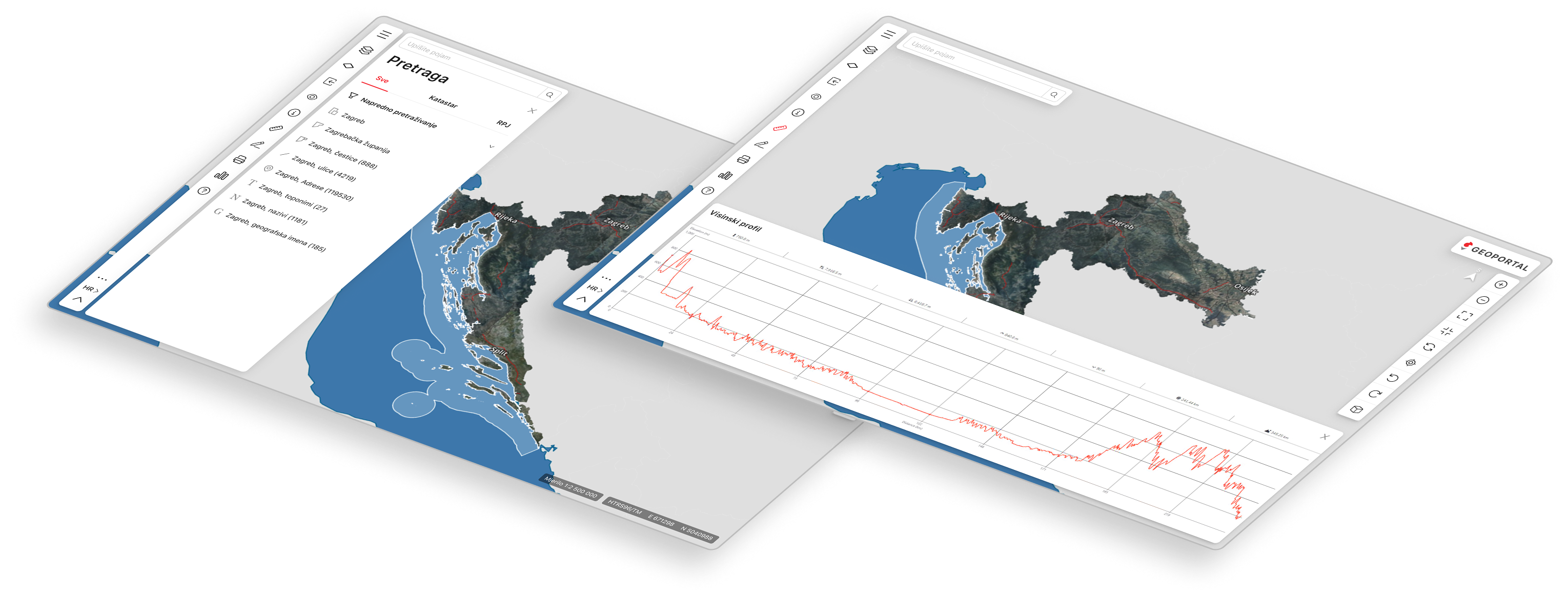
In addition to standard tools for managing digital maps, such as zooming in and out, Geoportal offers advanced options such as selecting active and basic layers, managing layers by adjusting transparency and order, displaying layer legends, loading external layers, and other functionalities. After adjusting the layers, users can draw, edit, measure, identify, and print the visible parts of the map and its elements. Geoportal is designed to meet the needs of different users, from beginners to advanced users, and provides intuitive tools for all experience levels.
Special attention was paid to the search engine due to the complexity of searching for information and the need for filters that enable precise and easy navigation. It is designed with a focus on intuitiveness, allowing users to apply different search criteria. The first task was to resolve logic and use case scenarios for Engeon (Verox’s original product), and then the same logic was applied to Geoportal’s search engine. Challenges included the application and management of filters, as well as the display of results, due to the massive database.
For all users who encounter the Geoportal for the first time, several forms of help are provided to make it easier for them to find their way around. A starter guide is available that provides basic information and steps for using the main functionalities. In addition, a detailed text guide explaining specific options and features of the system is integrated into the CMS part of the portal. Additionally, the help tool allows users to quickly find answers or instructions, making the whole process more accessible and simple for new users.

CMS API integration

In addition to map management, Geoportal also serves as a classic website where users can find additional content, the latest news, information about available services and functionalities, and details about Geoportal itself. It is also possible for users to log into their profiles, which gives them access to additional options.On the technical side, the CMS part of the Geoportal is integrated with the help of an API service, which enables efficient communication between different parts of the system. This approach ensures that administrative users can manage data and content from one centralized platform, without the need to switch to different systems. In this way, greater flexibility and ease of maintenance are achieved, while API services enable fast and reliable transfer of information between the user interface and the backend system.

Responsiveness and UI

The base of the user system was defined through the Ant design system, and all components, elements, and variables were built with its help. An important client request was visual clarity and emphasis on the maps, which inspired the concept of floating elements that were placed in the corners of the screen to free up as much space as possible for the map. In addition to the user interface, a new logo was designed that carries several associations connected to the work of the Geoportal: a pin as a universal symbol for marking a location, a capital letter G representing the initial letter of the Geoportal, and a globe, which symbolizes the global aspect of spatial data.

The hiccups and resolutions

The redesign of the Geoportal brought several challenges that required creative problem-solving. One of the main obstacles was balancing the complexity of geospatial tools with an intuitive user experience. Early iterations of the interface were overloaded with controls, making navigation overwhelming for casual users. This issue was addressed through multiple rounds of user testing, leading to a refined design with grouped functionalities and progressive disclosure, ensuring that advanced tools remained accessible without cluttering the interface.

Another challenge arose with the search functionality. Given the vast database, initial designs struggled with presenting search results in a clear and efficient manner. Users found it difficult to filter and interpret the data quickly. To overcome this, the filtering system was reworked to include categorized results and interactive previews, helping users navigate large datasets with ease. These challenges reinforced the importance of adaptability in UX design, emphasizing user feedback and iterative improvements to create a more seamless and user-friendly experience.